Purisima Creek Redwoods Open Space Preserve:
5.8 miles one-way for hikers; 7.5 miles one-way for multiuse route; car shuttle possible. Wheelchair users can access a 0.3-mile trail
From: East Purisima Creek Trailhead
To: Preserve’s Northeast Entrance in Woodside
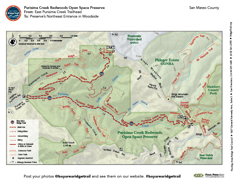
Five trails in Purisima Creek Redwoods Open Space Preserve link together for a challenging loop through forested canyons and over high ridges with ocean views. Hikers lose more than 1,000 feet of elevation in the first 2 miles and regain it on a steady climb out of the canyon (bicyclists and equestrians have a greater elevation loss and gain). The Craig Britton Trail for hikers is a relatively level trail through a majestic redwood forest. Summer fog sometimes bathes the forested areas, while the open, south-facing ridges may be hot.
Elevation Gain/Loss 1,215 feet/1,290 feet one-way for hikers; 1,710 feet/1,675 feet one-way for multi-use route
OuterSpatial Mobile Map: Click Here
Must have the OuterSpatial app for the link to take you directly to the mobile map page.
This trail description is excerpted from the 2019 Guidebook. For details on all trails, trailheads and more buy the book from Wilderness Press.
For more resources to plan your trip, visit our Trail Tools page.